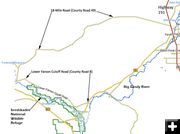

Road Closure map
Sweetwater County Road Closure Map courtesy Sweetwater County Sheriff's Office, 3/13/17
|
|
Sweetwater County flooding & road closures
18-Mile Road and Lower Farson Cutoff Road washed out and impassable
by Sweetwater County Sheriff’s Office
March 13, 2017
ROCK SPRINGS, WYOMING – March 13, 2017, 2:30PM: The Sweetwater County Department of Public Works and Sheriff Mike Lowell are advising that two county roads have been closed due to serious flooding.
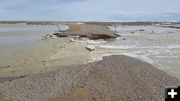
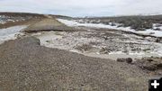
County Road 49, (the 18-Mile Road), and County Road 8, (the Lower Farson Cutoff Road) are badly washed out and impassable.
County Road 49, (the 18-Mile Road), runs from the Seedskadee National Wildlife Refuge on the Green River generally east to Highway 191; County Road 8, (the Lower Farson Cutoff Road), begins at Highway 28 and travels generally west along the Seedskadee Refuge’s northern boundary. The entire lengths of both roads are closed.
Lowell said the worst washouts are from water coursing down the Buckhorn Canyon drainage, which intersects both county roads.
County officials recommend in the strongest possible terms that the closures not be ignored.
"Especially if you are towing a trailer of some sort, you’re going to be in big trouble if you encounter an impassable spot and have to turn around," Lowell said.
|


