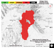
High Avalanche Danger at all elevations in western Wyoming
by Pinedale Online!
February 14, 2019
The Bridger-Teton National Forest Avalanche Center has issued a "Stern Wyoming Avalanche Advisory" for the mountains of western Wyoming. 10-14 inches of new snow fell on Wednesday,, February 13th, up to 9 inches on Togwotee Pass, and 7 inches on Blind Bull Summit and Commissary Ridge in the Greys River area of the Wyoming Range. Southwest to west winds at 30 to 50 with gusts from 45 to 75 miles per hour have caused substantial drifting. A slide ran onto the highway south of Jackson around 12:30 PM on Wednesday. One vehicle was hit, however no one was injured. Another slide released on a southeast aspect above Jackson and temporarily blocked the flow of Flat Creek.
Heavy snowfall is forecast to resume on Thursday evening. Forecast snowfall totals for the next 24 hours are 10 to 20 inches in the mountains and 4 to 8 inches in the valleys of western Wyoming. Southwest winds will also continue at speeds of 30 with gusts to 50 miles per hour. Temperatures will be on the increase and will rise into the upper 20s in the mountains and well into the 30s in the valleys.
The Bridger-Teton National Forest Avalanche Center has issued an avalanche warning effective until 5 PM Thursday evening. This warning may be extended or discontinued as conditions warrant. The warning is in effect for all three of our forecast zones and includes the valleys in those areas.
Strong winds, warming temperatures and heavy snowfall have created very dangerous conditions at all elevations. Natural avalanche activity may become widespread, especially during the overnight hours. Large avalanches could impact roadways in the river canyons, on Teton Pass and beneath buttes and steep hillsides. Steep hillsides, steep banks and road cuts have and are likely to slide. Slides are possible on steep slopes that may not normally slide. The general avalanche hazard is high at all elevations. Travel in avalanche terrain is not recommended.
|
