Fall to Winter in one day
3-6 inches of snow in mountains
October 4, 2005
Monday we were talking about wildfires, today snow is falling in Pinedale. Cold air and a developing storm system are combining to bring periods of snowfall to the Upper Green River Valley Tuesday.
The National Weather Service out of Riverton has issued a Snow Advisory for until midnight Tuesday. Five to ten inches of snow is expected in the mountains. Elevations below 7,500 feet are expected to get 3-7 inches of snow Tuesday. A Snow Advisory means that periods of snow will cause primarily travel difficulties with snow-covered roads and limited visibilities.
A wintery mix of rain and snow is expected throughout Tuesday at lower elevations, with much of the snow melting as it falls. Travelers are advised to check current road conditions before they depart. Online webcams and frequently updated road reports can be found at the Wyoming Department of Transportation website: Western Wyoming WYDOT Road Report.
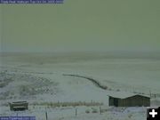
Snow is expected to accumulate in the mountains, with some places possibly getting up to a foot of new snow. Snow may also reach the valleys in various locations across Wyoming. Snow is visibly accumulating on the ground in Big Piney as of 9 am Tuesday, October 4, and is starting to flurry in Pinedale.
Another storm is possible for next weekend, bringing another round of cold rain and mountain snow late Saturday through Sunday. Locals can tune into KPIN 101.1 FM radio for breaking local news and weather.
Wyoming Highway Patrol Troopers have been busy on the west side of the state investigating numerous minor traffic crashes and vehicle slide-offs due to winter driving conditions brought on by snowfall and fog.
At this time no serious traffic problems or crashes have been reported. Snow, snow/rain mixed and rain continues to fall at various locations. In the southwest portion of the state the Evanston area is receiving snowfall with the roads currently wet. In the northwest portion of the state snowfall continues with roadways slushy, slick in spots and wet. Some locations are also experiencing foggy conditions.
As of Tuesday morning, Togwotee Pass is receiving snowfall with slick road conditions and WYDOT has advised no unnecessary travel over the pass. Troopers are working several slide-offs on the pass.
The Wyoming Highway Patrol (WHP) would like to remind drivers that a primary cause of crashes during winter conditions is driving too fast for conditions. The posted speed limit may not be a safe speed to travel when road conditions are other than dry. Slow down and never drive faster than you can see to react to sudden hazards.
WHP also urges motorists to be thinking of preparing their vehicles for the winter weather conditions. "Make sure your vehicle is up to the trip. If you currently do not have snow tires or mud/snow tires, you should get them. Check all of your vehicles fluid levels, windshield wipers, heater/defroster, anti-freeze protection and all exterior lights. Make sure all windows are free from snow/ice before you start. Check your fuel and gas up when you have ˝ tank left. This way, you will have enough fuel to stay warm if you become stranded along the route. As always, wear your seat belt on every trip, no matter how short or long the trip will be."
Motorists in Wyoming can get the current road conditions on their cell phone by dialing "#ROAD". Hunters: Visit the Sublette County Sheriff's Office Search & Rescue web page for tips for hunters.
Weather Forecast:
Tuesay: Snow likely, mainly after noon. Cloudy, with a high near 45. Breezy, with a west northwest wind between 15 and 22 mph, with gusts as high as 33 mph. Chance of precipitation is 70%. New snow accumulation of less than one inch possible. Tuesday Night: A 40 percent chance of snow before midnight. Mostly cloudy, with a low around 22. Northwest wind between 10 and 18 mph, with gusts as high as 28 mph. New snow accumulation of less than a half inch possible.
Wednesday: Mostly sunny, with a high around 51. Northwest wind 8 to 10 mph becoming southeast. Wednesday Night: Mostly clear, with a low near 20. South southeast wind between 3 and 8 mph.
Thursday: Mostly sunny, with a high around 57. North northwest wind between 5 and 7 mph. Thursday Night: Mostly clear, with a low around 24.
Friday: Partly cloudy, with a high around 60. Friday Night: Partly cloudy, with a low around 24.
Saturday: Partly cloudy, with a high near 55. Saturday Night: Partly cloudy, with a low near 22.
Sunday: Partly cloudy, with a high around 58. Sunday Night: Partly cloudy, with a low around 22.
Columbus Day: Partly cloudy, with a high near 61.

Related Links
Triple Peak Webcam - View of the Wyoming Range, direction weather typically comes
|
|