
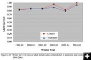
Mule Deer Doe Survival
Winter survival rates for radio-collared mule deer doe in the PAPA and Wind River Mountain front range areas betweeen 1999 and 2005. WEST Inc. graphic.
|
|
Sublette Mule Deer Report released
Phase 2 of long-term monitoring plan in PAPA
October 9, 2005
Wildlife Biologists working for Western EcoSystems Technology Inc (WEST Inc), have released a report on Phase II of their long-term monitoring of mule deer herds in Sublette County to assess impacts of energy development in the Pinedale Anticline Project Area (PAPA).
Biologists concluded in the report that "Estimates of deer abundance on the Mesa have significantly declined since development began. To date, our findings suggest seasonal timing restrictions may not be achieving desired results."
According to the report, "the number of producing well pads and associated human activity may negate the potential effectiveness of timing restrictions on drilling activities as a means to reduce disturbance to wintering deer. Reducing disturbance to wintering mule deer may require restrictions or approaches that minimize the level of human activity during both production and development phases of wells."
The Phase II report is a cooperative project paid for with funding from Questar Exploration and Production Company, TRC Mariah Associates Inc, the Bureau of Land Management (BLM) and the Wyoming Game and Fish Department. Research for the project was done by Hall Sawyer, Ryan Nielson, Dale Strickland, and Lyman McDonald working for WETI out of Cheyenne, Wyoming. The 58-page report is dated October, 2005. The entire report can be found in the links at the end of this article.
The two-phase Sublette Mule Deer Study began in 1998, largely funded by Ultra Petroleum, due to concerns over energy development on important winter game range on mule deer populations in the county. The first phase provided detailed information about the herd population, seasonal ranges, travel routes and survival rates. Phase I was completed in March, 2001 (see related links below for that report). The second phase began in December, 2002, and was designed as a before and after monitoring study using an undisturbed control group and impacted herds in the energy development impact areas south of Pinedale.
During Phase II for this report, animals in the PAPA were compared with a control mule deer herd along the western slopes of the Wind River Mountain Range. The Wind River front range herd used an area from Big Sandy north to Willow Lake. Biologists monitored adult doe survival, over-winter fawn survival, reproduction, and abundance as parameters in the PAPA and control areas, with comparisons made over time to determine the potential impacts of energy development on mule deer.
Report highlights:
* Mule deer on and adjacent to the PAPA annually migrating 60-100 miles between winter and summer ranges.
* 77 mule deer were GPS and radio-collar monitored in the study area over a 6-year period (1998 to 2003). Data collected accurately identified winter distribution, movement patterns, and migration routes of the marked deer on and adjacent to winter ranges.
* Based on satellite imagery, approximately 3 miles of new roads and 221 acres of well pads were constructed on the Mesa between September 2003 and August 2004. Approximately 5% of total surface disturbance was associated with road building, while the other 95% was attributed to well pad construction.
* During the harsh 2003-04 winter, biologists were able to document weather-related shifts in animal distribution.
* Although winter distribution patterns varied among deer in the control area, the migration route to northerly transition and summer ranges was surprisingly consistent. * All GPS-collared deer captured in the Pinedale Front migrated along a distinct movement corridor located at the base of the Wind River Range. Deer followed a well-defined route that narrowed to Ľ-mile in some areas, but rarely exceeded 1-2 miles in width. Knowledge of this migration route should provide agencies with the necessary information to maintain deer movements through the Pinedale Front, adjust harvest strategies accordingly, and prioritize habitat enhancement projects. Because several thousand mule deer rely on this migration corridor to access their seasonal ranges, maintenance of the corridor should be a priority for agencies, industry, and conservation groups.
* Predictive maps suggest that some areas categorized as high use prior to development, changed to low use as development progressed, and other areas initially categorized as low use changed to high use. Assuming habitats with high probability of use prior to development were more suitable than habitats with lower probability of use, these results suggest natural gas development on the Mesa displaced mule deer to less suitable habitats.
* Individual point estimates of over-winter adult and fawn survival were not statistically different between treatment and control areas. The long-term trends suggest deer in the treatment may not be performing as well as deer in the control. Reduced over-winter fawn survival, lower adult survival, and emigration are likely responsible for the population changes on the Mesa.
WEST Inc Big Game Reports
|