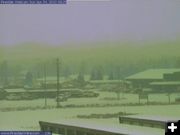
Pinedale View
View from the Pinedale webcam on Monday morning, April 5th. The Wrangler Cafe is on the left. NAPA Auto parts on the right. Storage units in the foreground. US 191 runs across the center of the image from left to right. On a clear day, the Wind River Mountains would be visible in the distance. More Pinedale area Webcams
|
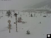
Bondurant View
View from the Bondurant webcam on Monday morning, April 5, 2010. The Bondurant valley has about 6 inches of snow on the ground.
|
|
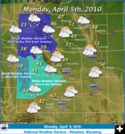
Winter Weather Advisory for April 5
3 to 9 inches new snow possible for Upper Green River Basin
April 5, 2010
The National Weather Service in Riverton has issued a Winter Weather Advisory for snow, which is in effect until 6AM Tuesday, April 6, for the Upper Green River Basin and South Lincoln County, including the towns of Pinedale, Big Piney, LaBarge, Farson, Kemmerer, Cokeville, Jackson, as well as the Gros Ventre and Wind River Mountains.
Light snow has begun across the area early Monday morning and will become steadier by mid morning. South to southeast winds will enhance snowfall Monday in the Upper Green River basin north of Big Piney and in the Upper Green River foothills.
A cold front will cross the area late Monday evening and will be accompanied by brief moderate to heavy snowfall. Snow will continue later Monday night and taper off around dawn.
Storm total accumulations of 3 to 6 inches are expected across most of the area. Lighter snow accumulations of 2 to 4 inches are expected in the southern Green River Basin. Higher accumulations of 6 to 9 inches will be possible in the northwestern Upper Green River foothills, including Bondurant.
Roads will be wet and slushy in spots and then become snow covered Monday evening and night. Travel could become hazardous after sunset.
A Winter Weather Advisory means that periods of snow and blowing snow will cause travel difficulties. Be prepared for slippery roads and limited visibilities, and use caution while driving.
Weather Forecast:
Monday: Snow showers likely before noon, then rain and snow showers likely. Some thunder is also possible. Cloudy, with a high near 39. Breezy, with a south wind between 17 and 20 mph. Chance of precipitation is 70%. Total daytime snow accumulation of 1 to 3 inches possible.
Monday night: Snow likely, mainly after midnight. Cloudy, with a low around 22. Southwest wind 7 to 16 mph becoming northwest. Chance of precipitation is 70%. New snow accumulation of 1 to 2 inches possible.
Tuesday: A 30 percent chance of snow, mainly before noon. Mostly cloudy, with a high near 32. Breezy, with a northwest wind between 18 and 26 mph, with gusts as high as 34 mph.
Tuesday Night: A 20 percent chance of snow. Mostly cloudy, with a low around 16. Blustery, with a northwest wind between 13 and 23 mph.
Wednesday: Mostly sunny, with a high near 38. Northwest wind between 11 and 15 mph.
Wednesday Night: Partly cloudy, with a low around 19. North northwest wind between 7 and 13 mph.
Thursday: Mostly sunny, with a high near 50. West wind between 3 and 6 mph.
Thursday Night: Partly cloudy, with a low around 18.
Friday: Partly sunny, with a high near 52.
Friday Night: Mostly cloudy, with a low around 24.
Saturday: Partly sunny, with a high near 52.
Saturday Night: Mostly cloudy, with a low around 23.
Sunday: A slight chance of rain and snow. Mostly cloudy, with a high near 50.
|