
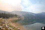
Middle Pine Lake
Photo taken Saturday, June 30th. Photo by Jason Curry. Great Basin IMT Team 5 Information Officer.
|
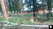
Protecting Summer Homes
Middle Piney Summer Homes. Photo by Jason Curry, Great Basin IMT Team 5 Information Officer.
|
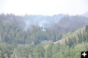
Smoldering
Photo taken Saturday, June 30th. Photo by Jason Curry, Great Basin IMT Team 5 Information Officer.
|
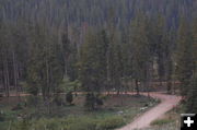
Campground work
Photo taken Saturday, June 30th. Photo by Jason Curry, Great Basin IMT Team 5 Information Officer.
|
|
Fontenelle Fact Sheet - Sunday, July 1, 2012
45,009 acres, 5% contained, community meetings planned for July 2 in Marbleton and Pinedale
by Great Basin IMT Team 5
July 1, 2012
Fontenelle Fact Sheet for Sunday, July 1, 2012 at 6:00 a.m.
Status: The Fontenelle Fire is burning on the Bridger-Teton National Forest, BLM High Desert District and State/Private Lands approximately 17 miles west of Big Piney, Wyoming. The fire began on June 24, 2012. The fire is currently 45,009 acres and burning in heavy, dead timber with occasional areas of grass and sage in the lower elevations.
Fire Statistics:
• 45, 009 acres burned
• 5% contained
• 427 Personnel on scene
Community Meeting: The current Incident Command Team will conduct public meetings in Pinedale and Marbleton on the evening of Monday, July 2, 2012. The exact time and location of the public meetings will be published tomorrow and can be found at www.Inciweb.org.
Recent Events: On Saturday, the Fontenelle Fire continued to progress northeast, crossing the Fish Creek drainage and becoming established on the south end of Fish Creek Mountain. However a decrease in winds yesterday slowed the overall spread of the fire, limiting yesterday’s growth to approximately 8,000 acres.
Today’s Strategy: Firefighters will construct and improve fire line along the southwest portion of the fire area today. Fire crews will continue to provide structure protection along the Middle Piney road north to the Middle Piney summer homes. Firefighters will utilize aerial support from helicopters that will operate from the Big Piney-Marbleton airport.
Forecast: The fire area will continue to be under a Red Flag warning today for gusty wind and low relative humidity.
Closures: Road closures at present extend from the forest boundary at the top of Bare Pass at Red Castles, west to N. Piney Meadows and Tri Basin Divide, south to Cheese Pass, Mount Isabel, and Red Park, east to the junction of LaBarge Creek Road and the forest boundary, and north to Bare Pass. Further closures may be needed to ensure firefighter and public safety. The public is asked to be cautious when driving on the LaBarge Road between Hwy. 189 to the closure at the forest boundary as there may be large fire engines, fire traffic and impact from smoke.
More Information:
www.fs.usda.gov/btnf
www.inciweb.org
www.tetonfires.com
Twitter: @WildeType2_IMT
Fontenelle Fire information phone: 307-276-3324
Related Links:
Fire Restrictions
Expanded Closure Map
Fontenelle Fire photo gallery
|