|
More
Current Fire Information:
More
lightning-caused small fires were reported on the Bridger-Teton National
Forest on the Pinedale and Big Piney Ranger Districts yesterday and today.
Fires were near Bondurant, on the Rim, in the Greys River District and
up in the northern portion of the Forest. All of these fires were less
than an acre in size and crews were able to either completely extinguish
them or contain them.
- The Table
Fire, located in the Snake River Canyon and east side of the river,
across from the East Table Campground was reported this morning at 8:00
AM and is estimated at 1/10 acre in heavy timber. Two members of the
Bridger-Teton National Forest Helitack crew have responded.
- The Jackson
Fire, which was also reported this morning, is located on the border
of the Bridger-Teton and Caribou-Targhee National Forests. This 1/10
spot fire is located two miles east of Powder Peak and is being responded
to by Helitack Crews from the Caribou Targhee National Forest.
Two smokejumpers are also assisting in suppression efforts.
- The North
Fork Fire, reported early this morning is located in the Teton Wilderness,
approximately 2 miles northeast of Turpin Meadows. Two smokejumpers
are working to suppress this 1/10-acre spot fire.
- The Jack
Fire is located on the Big Piney Ranger District in the Jack Creek
drainage, east of Bondurant, WY. An Engine crew from the Bridger-Teton
National Forest has responded with three crewmembers.
- The Crossley
Fire, located in the Greys River Ranger District is being responded
to by smokejumpers.
-
The
Jenny Fire reached ¼ acre on the Big Piney Ranger District,
3 miles east of Bondurant, WY, in the Jenny Creek Drainage. Supported
by one helicopter performing water drops, and was controlled by engine
crews from the Bridger-Teton National Forest and the Bondurant Volunteer
Fire Department.
- The Red
Fire was located approximately one mile southeast of the Whiskey
Grove Campground on the Green River in the Pinedale Ranger District.
This lightning caused fire burned 1/10 of an acre and was contained
by 6 crewmembers from the Bridger-Teton National Forest who were also
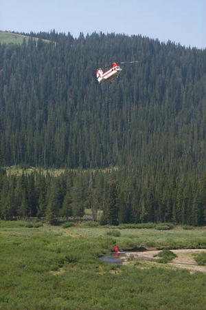
supported by a single helicopter performing water bucket operations.
-
The
Mail Box Fire was located approximately 6 miles northeast of
Bondurant, WY near Rock Creek, south of Tin Can Park on the Big Piney
Ranger District. This fire reached ¼ acre in size.
-
The
Elk Fire, was located five miles southeast of Bondurant, WY,
two miles south of Robinson Butte on the Big Piney Ranger District.
This 1/10-acre fire was contained by 4 crewmembers supported by a
helicopter performing water bucket operations.
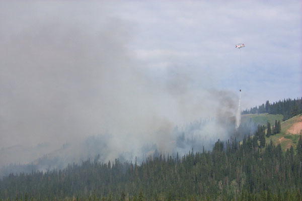
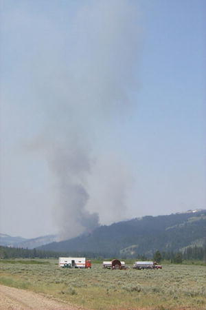
 The Mule Fire size reached 3,855 acres today and is 20% contained.
Rain from thunderstorms helped slow the fire down a bit both yesterday
and today. The fire continued to spot on the northeastern edge in Mill
Creek and Dry Beaver Creek drainages. These spots in the heavily timbered
areas are the primary targets of suppression activities. Crews have been
successful in holding the southern edge of the fire on Horse Creek Road.
The Mule Fire size reached 3,855 acres today and is 20% contained.
Rain from thunderstorms helped slow the fire down a bit both yesterday
and today. The fire continued to spot on the northeastern edge in Mill
Creek and Dry Beaver Creek drainages. These spots in the heavily timbered
areas are the primary targets of suppression activities. Crews have been
successful in holding the southern edge of the fire on Horse Creek Road.
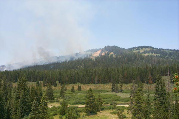
Private structures are located within 5 miles to the
east of the fire adjacent to the Forest, but these structures are not
immediately threatened. Currently there are twelve 20-person hand
crews, four ten-person camp crews, three helicopters, three air-tankers,
three dozers, nine wildland engines, two lead planes and a Type II National
Incident Management Team fom North Carolina.
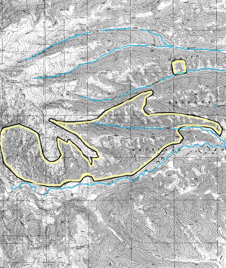
The
fire is located approximately 20 miles west of Daniel with its  eastern
edge six miles west of the Sherman Guard Station. It is one mile north
of Prospect Peak and approximately one mile south of Horse Mountain on
the Big Piney Ranger District. The fire base is located on the Cottonwood/Ryegrass
road, moved from Sherman Guard Station to get more distance away from
the fire and out of the path of the smoke. The fire command team is performing
a structural protection analysis as a precautionary step in case the fire
begins to threaten private structures adjacent to the forest. See the
PDF links above for detailed maps showing the current fire perimeter and
an area map showing a broader view of the fire in relation to Daniel,
Hoback Ranches and Beaver Ridge. eastern
edge six miles west of the Sherman Guard Station. It is one mile north
of Prospect Peak and approximately one mile south of Horse Mountain on
the Big Piney Ranger District. The fire base is located on the Cottonwood/Ryegrass
road, moved from Sherman Guard Station to get more distance away from
the fire and out of the path of the smoke. The fire command team is performing
a structural protection analysis as a precautionary step in case the fire
begins to threaten private structures adjacent to the forest. See the
PDF links above for detailed maps showing the current fire perimeter and
an area map showing a broader view of the fire in relation to Daniel,
Hoback Ranches and Beaver Ridge.
Fire
restrictions will go into effect beginning Thursday, July 18th on the
Bridger-Teton National Forest and in Grand Teton National Park. The fire
danger has been elevated to Very High as of Tuesday, July 16th. Daily
Forest Service press release updates for this fire are available from
the Bridger-Teton National
Forest fire page. For more information, contact the Bridger-Teton
National Forest at (307) 739-5500 or call the new toll-free information
hot line numbers.
Other
area fires:
Fires are currently burning in Yellowstone National Park and Grand Teton
National Park. The Teton Fires web site also has interagency fire information
links for the Bridger-Teton National Forest, Grand Teton National Park
and Yellowstone National Park, www.tetonfires.com.
The public is encouraged to report any new smoke columns they see. You
can keep up with where the fires are burning by checking in on the National
Interagency Fire Center (NIFC) Large
Fire update page and Fire
Map.
|
Fire
Page Sponsor
|